
A larger, high resolution version of the European regions map:
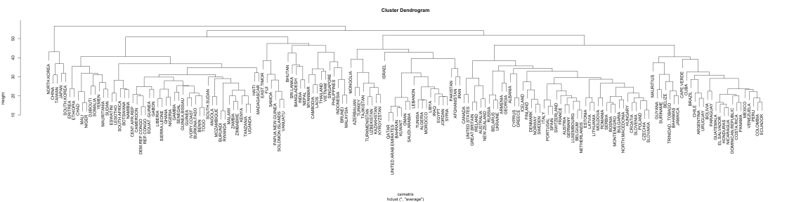
The Country Similarity Index attempts to quantify how similar countries are to each other relative to other countries. The index is a statistically-based way to measure this. It weighs equally five major aspects of countries: their demographics, culture, politics, infrastructure, and geography. The methodology is exactly the same for each country.
The data from the Country Similarity Index was used to cluster European countries into different regions and to create the most accurate regional map of the continent. This resulted in 7 distinct macro-regions:
- Northwestern Europe
- Northern Europe
- Western Europe
- Southeastern Europe
- Albanian Europe
- Eastern Europe
- Northeastern Europe
It must be noted that these macro-regions still have very significant differences within them. Countries as different as Estonia and Bosnia are still grouped together. To account for this, the 7 macro-regions were further divided into 13 sub-regions. It is hoped that this study has created a more rigorous and logical regional map of Europe than any previously created. Please see this article, which compares these groupings to other regional maps created by geographers.
The countries in each region and their individual pages are as follows:
Northeastern Europe
Western Europe
Northern Europe
Southeastern Europe
Albanian Europe
Eastern Europe
- Bosnia & Herzegovina, Serbia, North Macedonia, Montenegro, Bulgaria
- Poland, Czechia, Slovakia, Hungary, Slovenia, Croatia
- Estonia, Latvia, Lithuania
- Moldova, Romania
Northeastern Europe
Here is the world’s hierarchical clustering dendrogram, the primary source of the European map’s regions:
Finally it may best to look at the European countries as a connected web, not hierarchical clusters.

Thank you for nothing
As a map enthusiast I can say that this is the best and most accurate map of European regions. Perhaps, three more sub-regions can be added. Europe divided in 16 countries one day?
i did not see much besides a bunch of adds
What about Malta?